
Last updated: October 7, 2024
In Brief
RESOLVE · One Earth
Global Safety Net
The Global Safety Net has been given an Honorable Mention in the AI & Data category as part of Fast Company's World Changing Ideas Awards 2021. Now in its fifth year, these awards honor products, concepts, companies, policies, and designs that are pursuing innovation for the good of society and the planet.

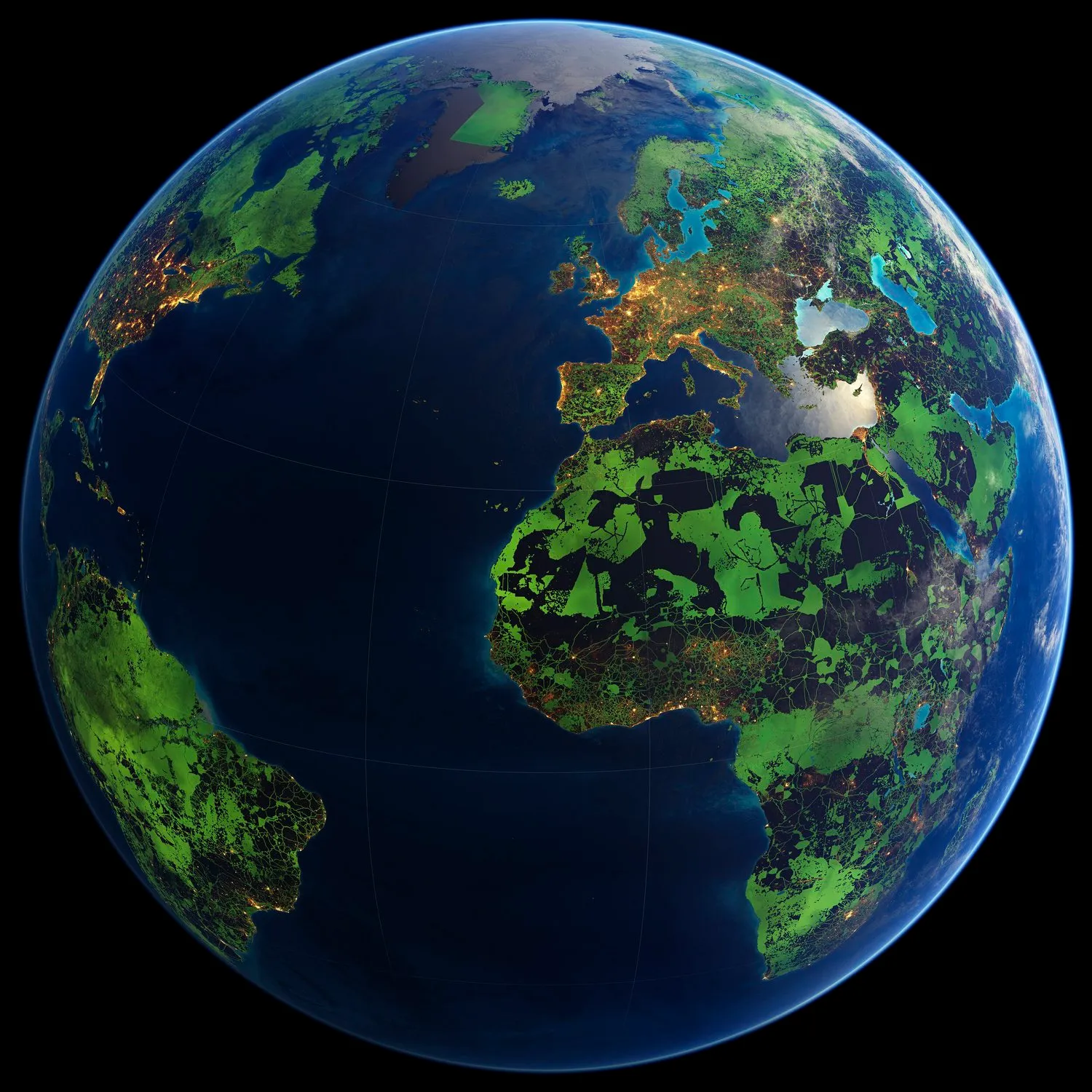
Piopiotahi (Milford Sound), Aotearoa New Zealand — atmosphere, hydrosphere, cryosphere, lithosphere and biosphere converge in a single frame. This delicate and dynamic balance is what is at stake. A stable and resilient planet is every child’s birthright. What we, individually and collectively, choose to do in the next 50 years will determine the next 10,000 years.
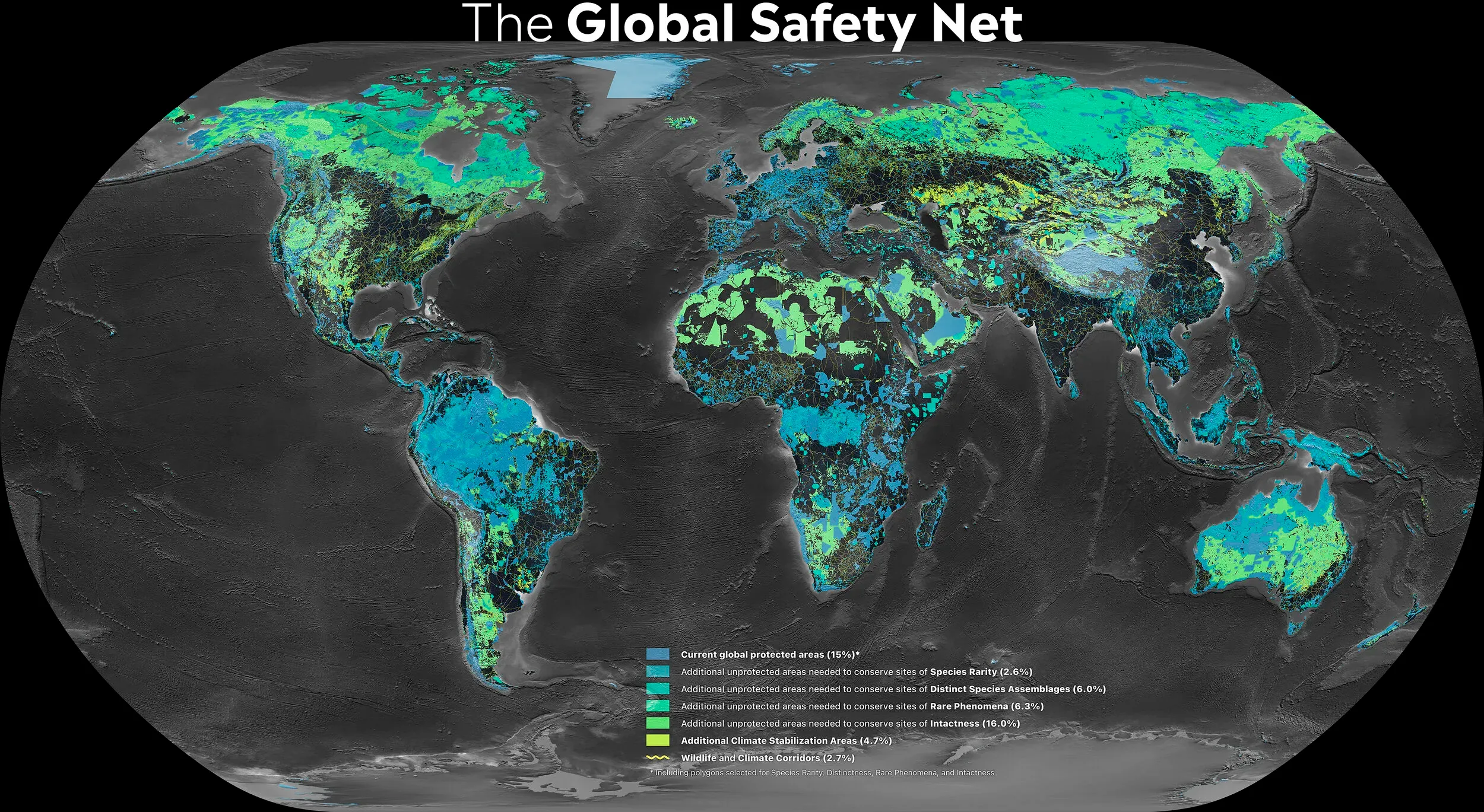
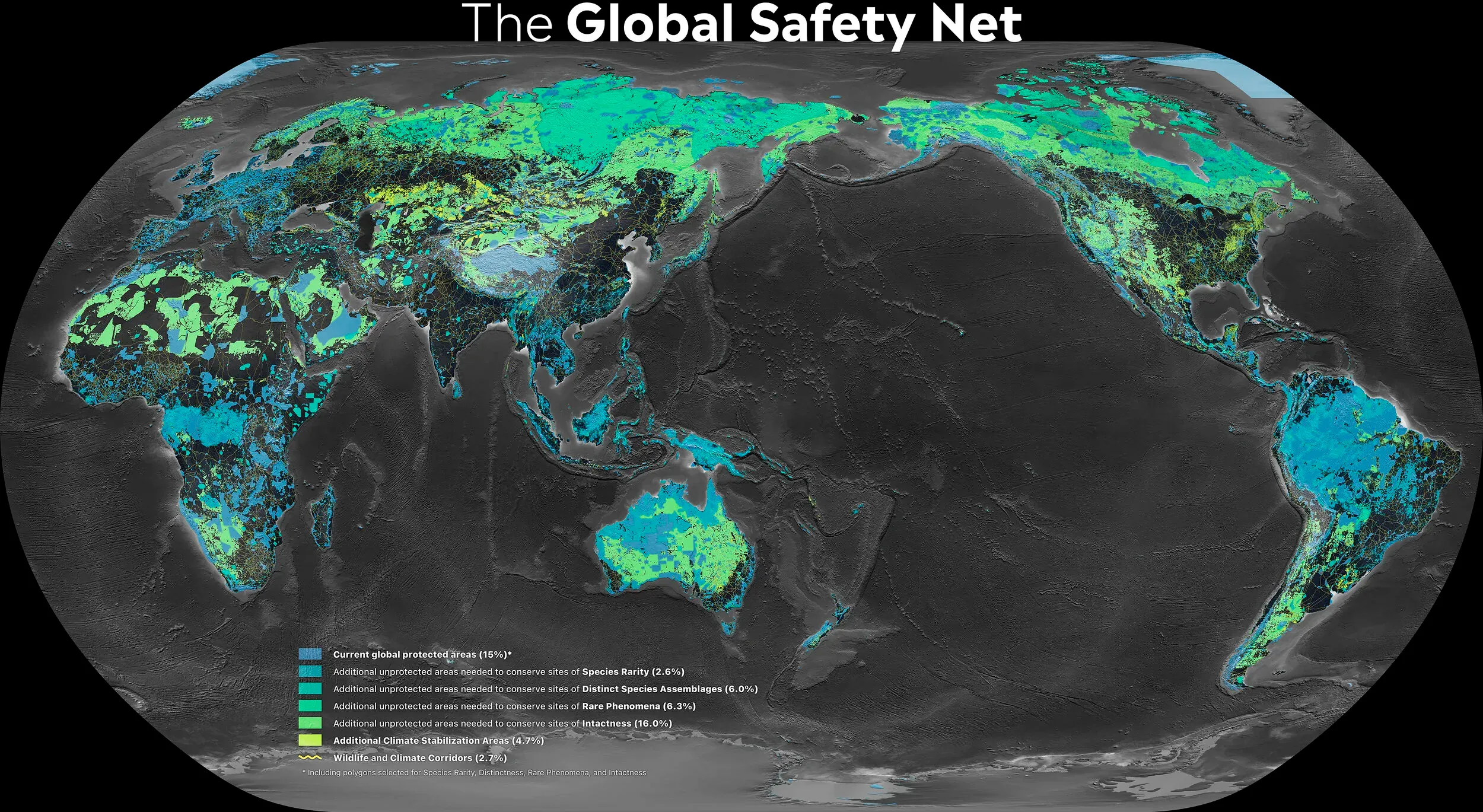
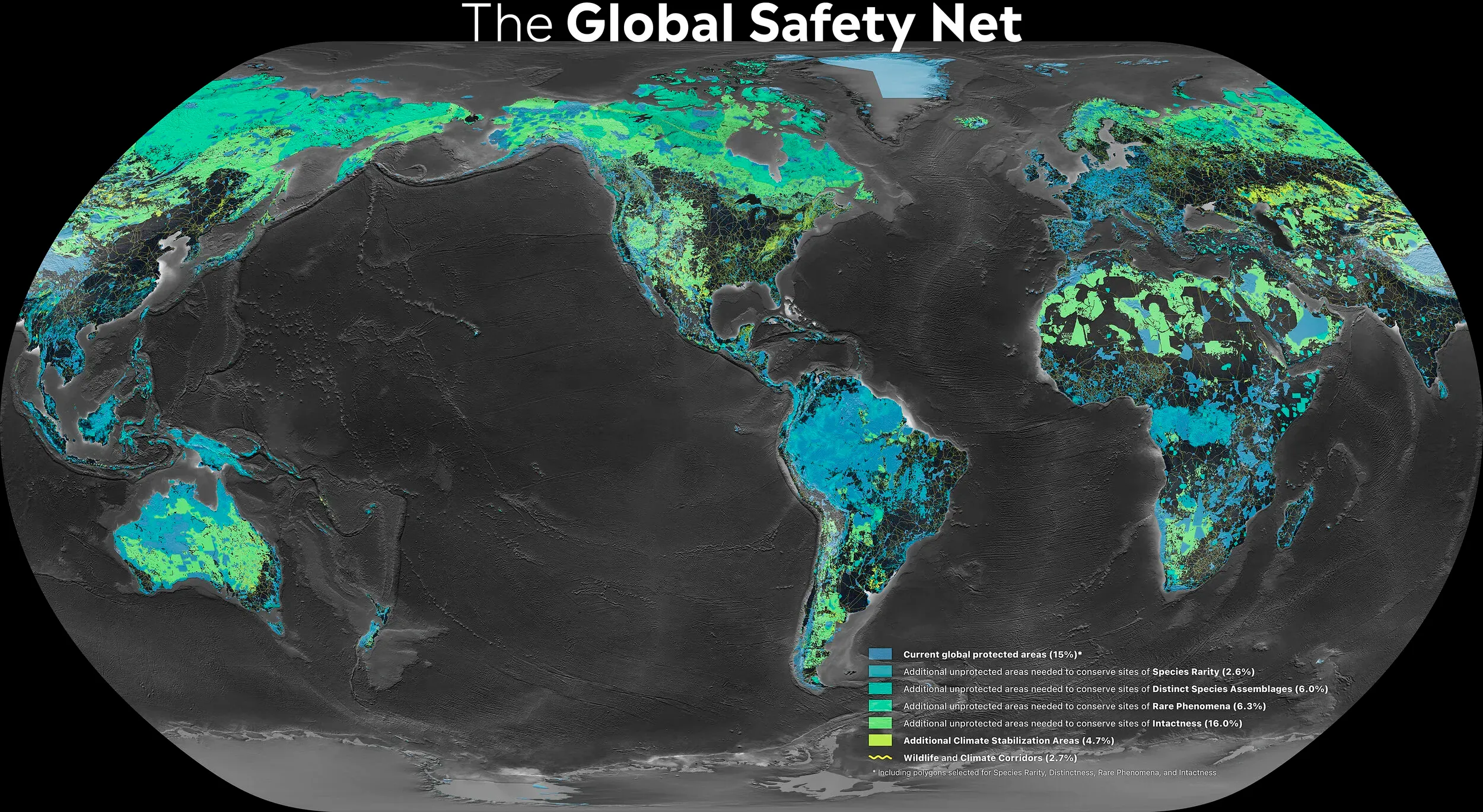
Global strategies to halt the dual crises of biodiversity loss and climate change are often formulated separately, even though they are interdependent and risk failure if pursued in isolation. The Global Safety Net, published in Science Advances in 2020, maps how expanded nature conservation addresses both overarching threats simultaneously. It identifies 50% of the terrestrial realm that, if conserved, would reverse further biodiversity loss, prevent CO₂ emissions from land conversion, and enhance natural carbon removal. Building on the foundational ecoregion framework of Dinerstein et al. (2017) and three years in development, the first version brings together the World Database on Protected Areas with 11 biodiversity data layers — organized into four clusters: species rarity, distinct species assemblages, rare phenomena (including the last intact large mammal assemblages), and intactness (remaining unprotected wilderness) — plus additional climate stabilization areas. Using the Global Deal for Nature as a guiding framework, it offers a spatially explicit, science-based blueprint to support multilateral, national, and subnational land use planning efforts.
A science-based blueprint for half of Earth
While the parallel crises have often been treated as separate policy domains, the evidence overwhelmingly shows they share the same solution: conserve enough nature and in the right places. Analyses designed to protect biological diversity have converged on the need to conserve and connect approximately half the Earth. Above 1.5 °C in global average temperature rise, many ecosystems would be unable to adapt and, with increased biodiversity loss, could collapse. Nature-based solutions offer essential means to achieving the global climate objective of staying below 1.5 °C — but more ambitious conservation targets will be required.
The Global Safety Net addresses this through three complementary targets:
-
Target 1 — Conserving the diversity and abundance of life on Earth. Eleven biodiversity data layers — organized into four clusters: species rarity (sites harboring narrow-range, endangered, and endemic species), distinct species assemblages (areas of high beta-diversity), rare phenomena (landscapes containing rare global phenomena, including the last intact large mammal assemblages), and intactness (remaining unprotected wilderness) — add 30.6% of unprotected land surface to the 15.1% currently protected (2020 baseline). Together with existing protected areas, these regions encompass 45.7% of the terrestrial realm where nature conservation should be a primary objective. Fifty ecoregions and 20 countries contribute disproportionately to these targets.
-
Target 2 — Enhancing carbon storage and drawdown. The spatial coincidence of areas important for biodiversity and carbon storage is striking: currently unprotected high-carbon areas (median total carbon above 215 metric tons per hectare) overlap extensively — 92% — with areas selected under Target 1. Where coverage from Target 1 is insufficient to meet climate objectives, additional climate stabilization areas bridge the gap, adding a further 4.7% of the terrestrial realm.
-
Target 3 — Wildlife and climate corridors. Connectivity is a time-bound issue of global consequence, yet most conservation plans fail to address potential climate corridors or interecological connectivity. Currently, only half of the 15.1% of terrestrial protected areas are connected. A system of comprehensive wildlife and climate corridors could connect the world’s remaining intact habitats and enable species movement in a rapidly changing world. This scoping exercise reveals that connecting all current and proposed Global Safety Net areas would require 3.6 million to 5.7 million km² of corridor land.
Together, these three targets bring the total area requiring conservation attention to 50.4% of the terrestrial realm. This figure is not arbitrary; it emerges directly from the additive compilation of science-based priorities for both biodiversity and climate.
Indigenous lands
The overlay of mapped indigenous territories with the Global Safety Net reveals an extensive overlap of 37% across targets 1 to 3, underscoring the central role that indigenous peoples and their lands play in preserving biodiversity and regulating Earth’s atmosphere. Greater than 74% of all mapped indigenous lands are tier 1 or tier 2 climate stabilization areas, and together these areas store more than 931,000 megatons of carbon biomass. Addressing indigenous land claims, upholding existing land tenure rights, and resourcing programs on indigenous-managed lands could help achieve biodiversity objectives on as much as one-third of the area required by the Global Safety Net — while simultaneously advancing social justice and human rights. In short, the “30 × 30” target is far less ambitious when viewed through this perspective: many conservation organizations, indigenous peoples, and local communities have called for an area-based target of “at least 50%” under the Convention on Biological Diversity.
Pandemic prevention
The need for an ambitious global conservation agenda took on new urgency in 2020 after the rapid spread of COVID-19. Global shifts in mammalian population trends reveal key predictors of virus spillover risk: extensive deforestation in the tropics has led to humans coming into greater direct contact with vector-borne pathogens and mammalian carriers that serve as viral hosts. Achieving the area-based targets to protect all remaining intact and semi-intact terrestrial habitats would be an effective solution to reduce contact zones, helping to limit the chance of zoonotic diseases from affecting human populations in the future. Conserving the Global Safety Net could thus support public health alongside biodiversity and climate goals.
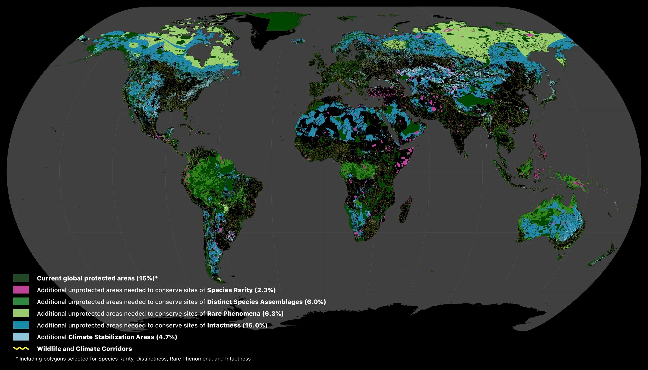
FIGURE 1 — Areas of the terrestrial realm where increased conservation action is needed to protect biodiversity and store carbon. Numbers in parenthesis show the percentage of total land area of Earth contributed by each set of layers. Unprotected habitats drawn from the 11 biodiversity data layers underpinning the Global Safety Net augment the current 15.1% protected with an additional 30.6% required to safeguard biodiversity. Additional Climate Stabilization areas add a further 4.7% of the terrestrial realm. Also shown are the Wildlife and Climate corridors to connect intact habitats (yellow lines).
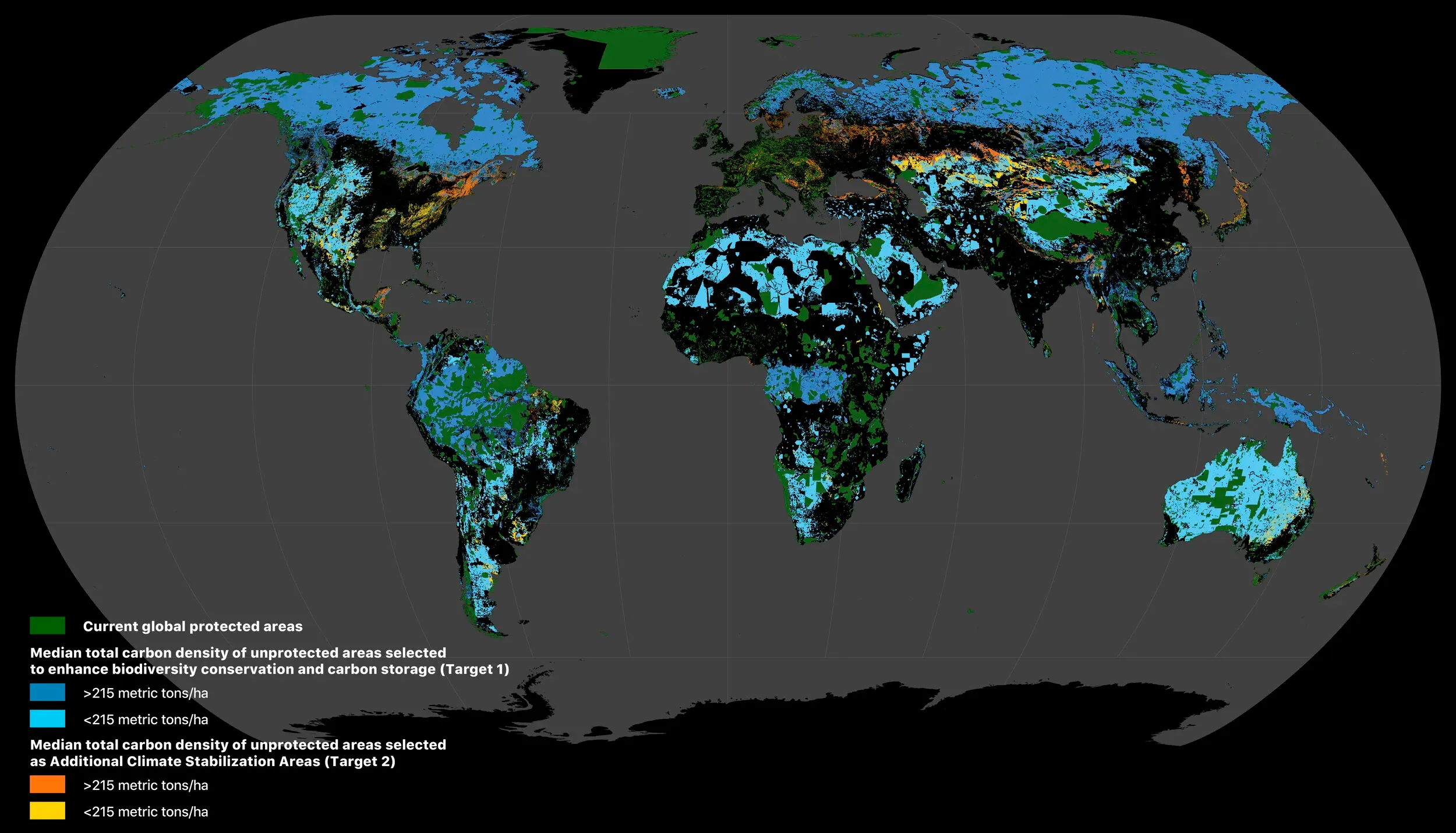
FIGURE 2 — Interdependence of carbon and biodiversity. Currently unprotected high carbon areas with median total carbon > 215 metric tons/ha overlap extensively (92.0%) with areas selected under Target 1, highlighting the importance of these lands for biodiversity conservation and climate stabilization. Other areas important for biodiversity but of lower carbon value, i.e. < 215 metric tons/ha, are also shown. Additional Climate Stabilization Areas (CSA), including Tier 1 and Tier 2 CSAs, are also selected to bridge the gap for adequate carbon storage beyond areas identified in Target 1.
A Global Safety Net for Biodiversity, Climate and Humanity
GSN1 | Alternative colors (centered on Africa and Europe)
GSN1 | Alternative colors (centered on East Asia and Australia)
GSN1 | Alternative colors (centered on the Americas)
Reference map.
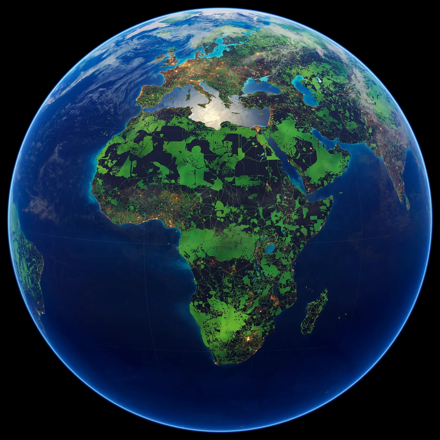
Global Safety Net — Africa
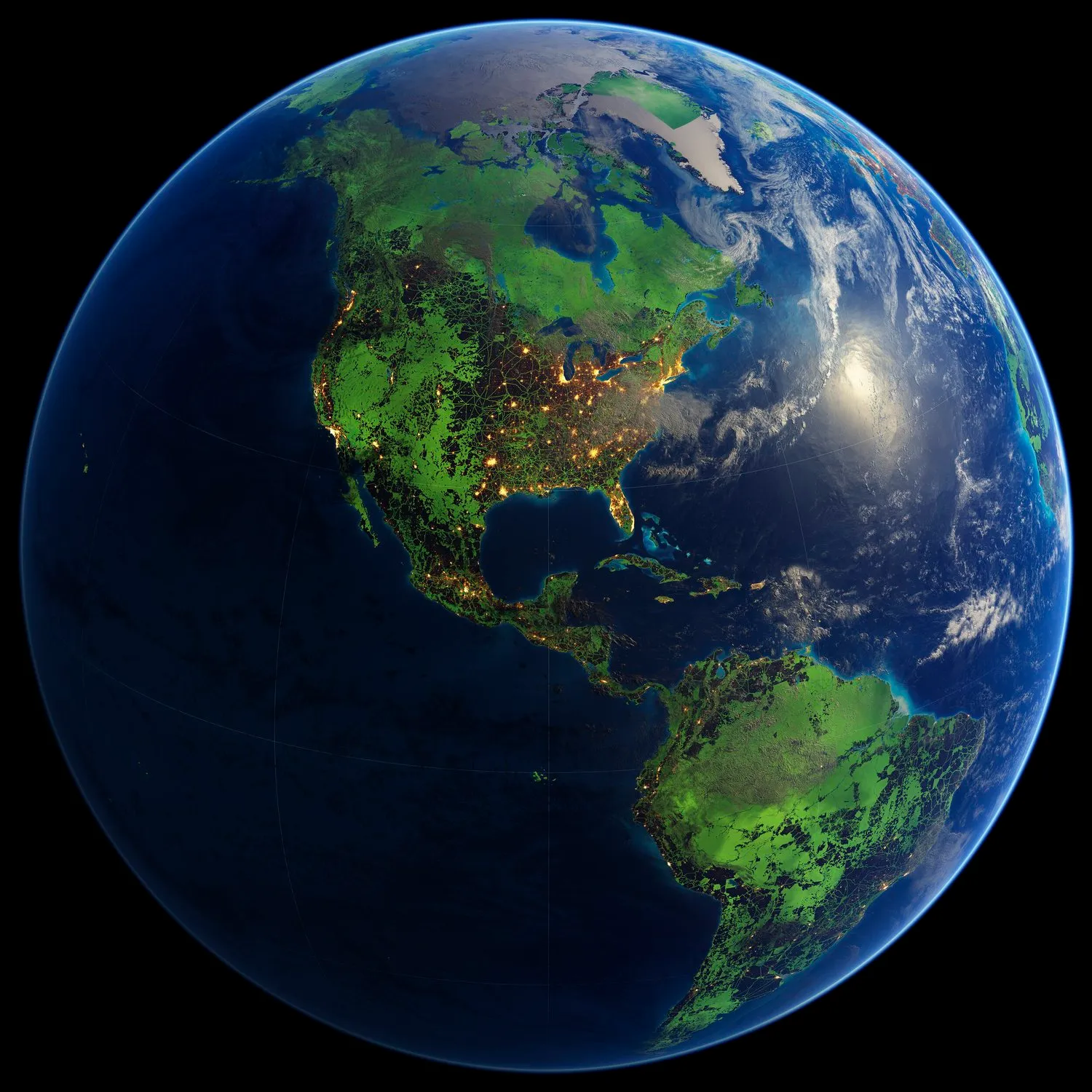
Global Safety Net — Americas
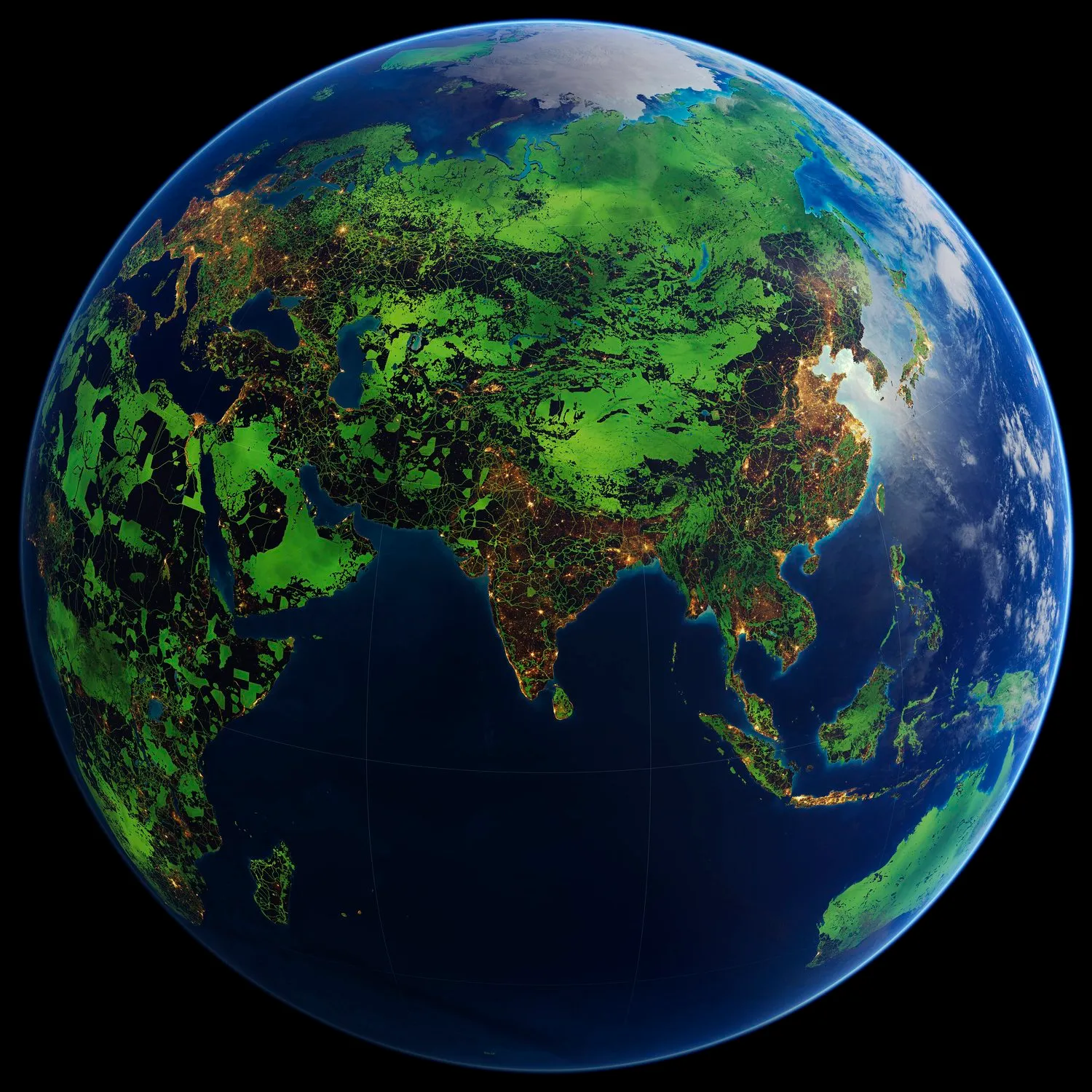
Global Safety Net — Asia
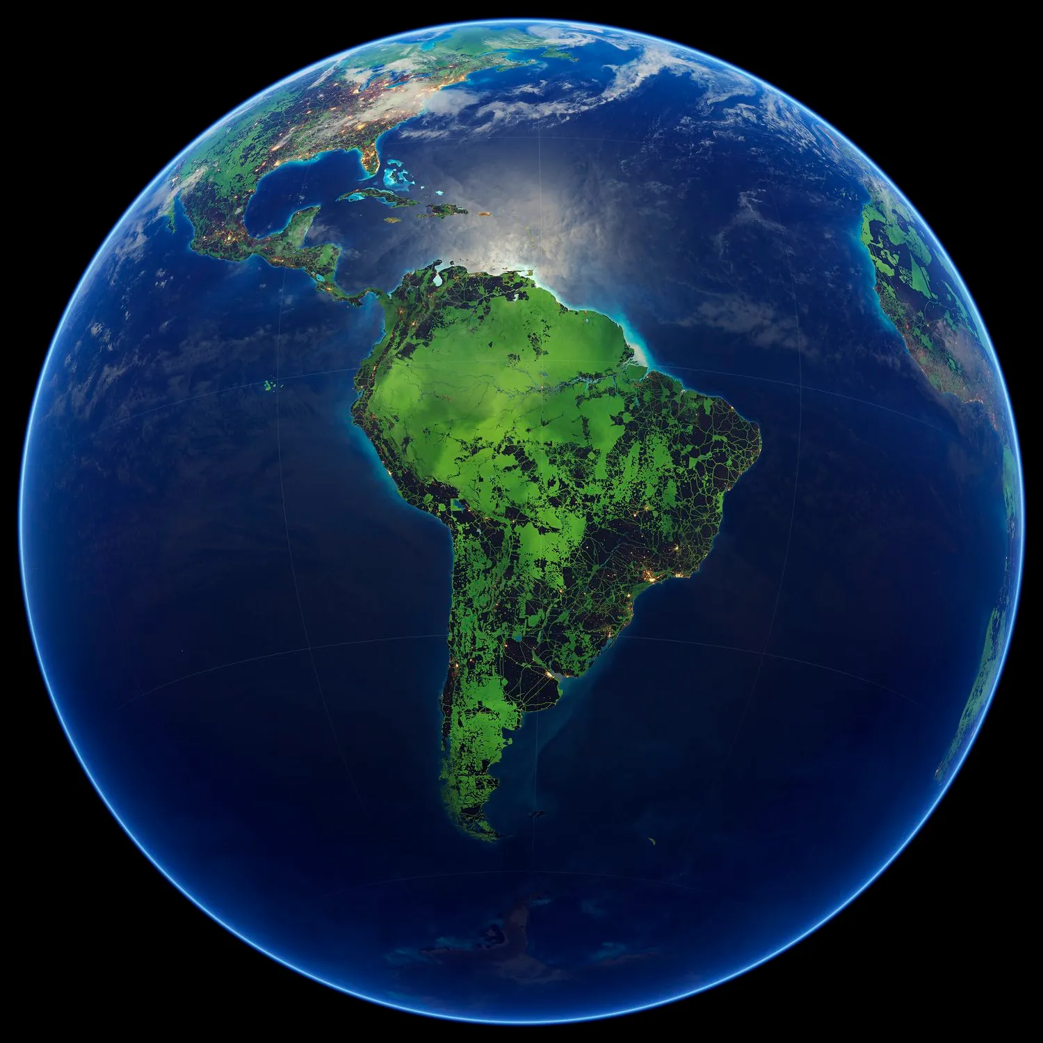
Global Safety Net — South America
Global Safety Net — Europe and Africa
Conservation Imperatives (2024)
Ambitious biodiversity goals to protect 30% or more of Earth’s surface by 2030 — the “30×30” target adopted at the UN Convention on Biological Diversity in Montreal in December 2022 — require strategic near-term priorities. Yet the expansion of global protected areas between 2018 and 2023 incorporated only 7% of sites harboring range-limited and threatened species, leaving the vast majority of these irreplaceable habitats at risk of conversion and degradation.
To address this gap, the research team defined Conservation Imperatives — 16,825 unprotected sites spanning approximately 164 million hectares (1.22% of Earth’s terrestrial surface) that harbor rare, range-restricted, and threatened species. These sites were identified by combining six widely used global biodiversity data layers — Alliance for Zero Extinction (AZE) sites, IUCN range rarity species, IUCN threatened species sites, Key Biodiversity Areas (KBAs), small-range vertebrate species, and range-restricted vascular plants — then overlaying them with a fractional land cover analysis using Copernicus satellite data at 100-meter resolution to remove areas that are no longer viable habitat (urban, agricultural, and degraded land). The result is a 46% reduction from earlier estimates of species rarity area, reflecting both habitat conversion already underway and methodological refinement.
Conservation Imperatives are highly concentrated: the four major tropical realms (Neotropic, Indomalayan, Australasia, and Afrotropic) account for 89% of all sites globally, and the top five countries — the Philippines, Brazil, Indonesia, Madagascar, and Colombia — together harbor 59% of all Conservation Imperatives. Over 87% of all sites occur in just 30 countries. Tropical and subtropical moist broadleaf forests alone account for three-quarters of all sites — yet this biome received only 2.4% of newly created protected areas between 2018 and 2023, revealing a critical misalignment between where protection is being expanded and where it is most needed. Had the 1.2 million km² added to the global protected area estate over the past five years been strategically located to cover Conservation Imperatives, 73% of these sites would now be under protection. Seventeen percent of Conservation Imperatives fall within current or historical Indigenous lands, further underscoring the role of Indigenous Peoples and Local Communities as stewards of irreplaceable biodiversity.
Preventing extinction is affordable
A critical finding is that protecting all Conservation Imperatives in the tropics would cost approximately US$169 billion (90% probability: US$146–US$228 billion), or roughly US$29–46 billion per year over five years. By comparison, global fossil fuel subsidies exceed US$7 trillion per year (IMF, 2023). Permanently protecting only 0.74% of land in the tropics — where Conservation Imperatives are concentrated — could prevent the majority of predicted near-term extinctions. Focusing even more narrowly on the 10 Neotropic ecoregions with the most sites would reach 23% of all identified sites at a cost of US$1.4 billion per year for five years. Thirty-eight percent of the 16,825 sites are either adjacent to or within 2.5 km of an existing protected area, potentially reducing land acquisition and management costs. Multiple approaches will be required: providing rights and titles to Indigenous Peoples and Local Communities conserving traditional lands, government designation of new protected areas on federal and state lands, and land purchase or long-term leasing of privately held lands.
These Conservation Imperatives can be thought of as “anchor points” for designing regional-scale conservation planning efforts under 30×30 — the most biologically important and threatened places to protect first.
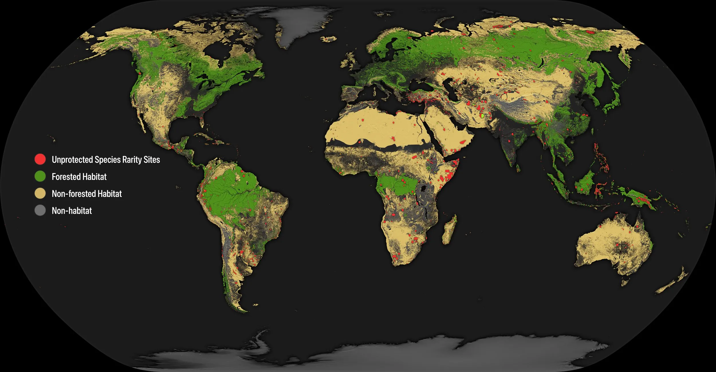
Global distribution of the unprotected species rarity sites (red area) across predominantly forested habitat (green) and non-forested habitat (yellow), with non-habitat areas (grey) removed from previously designated species rarity sites, covering 1.22%. Non-habitat areas include land classified as urban, agricultural, and degraded.
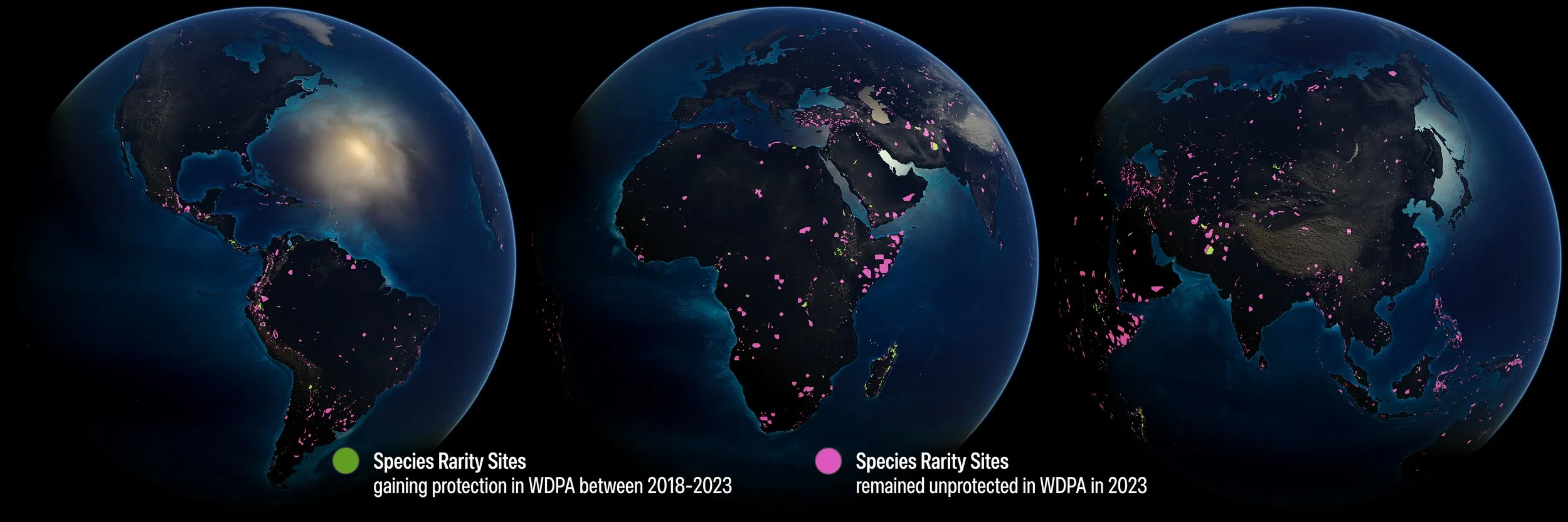
Expansion of protection in species rarity sites in World Database on Protected Areas (WDPA) between 2018 and 2023 after overlaying the fractional land cover. Green polygons show unprotected species rarity sites that have gained protection between 2018 and 2023, representing only 7% of the global increase in protection coverage. Magenta polygons represent sites that remain unprotected in 2023.
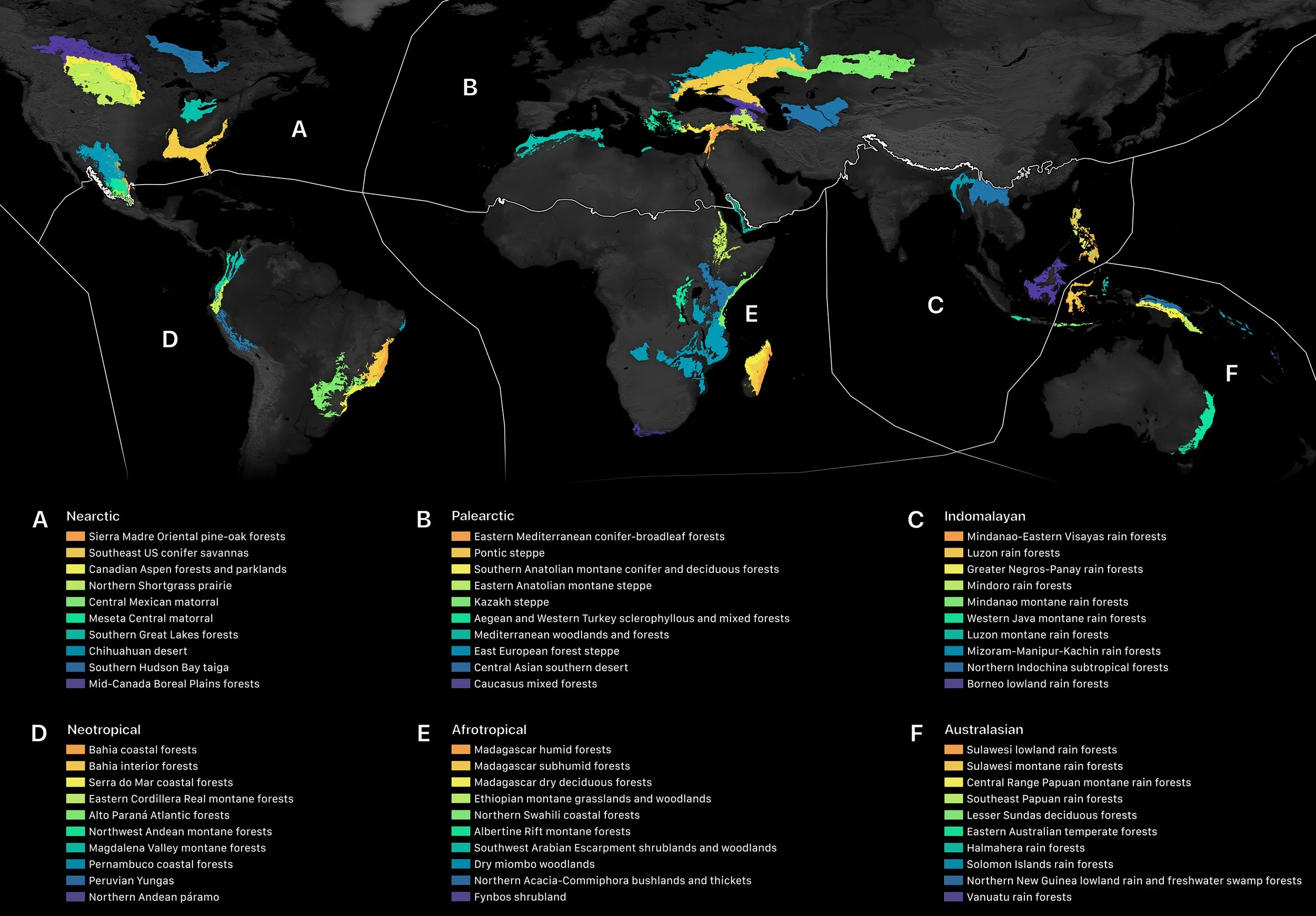
The 10 ecoregions in each realm containing the highest number of Conservation Imperatives.
Iconic Species Index (coming soon)
A third research program with RESOLVE and One Earth is currently in development. The Iconic Species Index will build on the Global Safety Net and Conservation Imperatives frameworks, further advancing the science of species-level conservation prioritization. GLOBAÏA is contributing data visualization. Details will be published here upon release.
Our contribution
GLOBAÏA created the data visualizations for both the Global Safety Net and Conservation Imperatives research programs, contributing geospatial mapping, globe views, and large-format visual compositions throughout a collaboration with RESOLVE and One Earth spanning several years. For the Global Safety Net (2020), GLOBAÏA provided visualization and figure editing. For Conservation Imperatives (2024), GLOBAÏA’s role expanded to include original draft writing, review and editing, and visualization — reflecting a deeper integration into the research process. GLOBAÏA has created numerous globe views to help evaluate and assess available datasets.
Early development of the Global Safety Net visualization was supported by the Leonardo DiCaprio Foundation, which funded the initial geospatial mapping and globe rendering work that would later inform the 2020 publication.
Early Global Safety Net visualization developed with support from the Leonardo DiCaprio Foundation.
References
Dinerstein, E., Joshi, A. R., Vynne, C., Lee, A. T. L., Pharand-Deschênes, F., França, M., Fernando, S., Birch, T., Burkart, K., Asner, G. P. & Olson, D. A “Global Safety Net” to reverse biodiversity loss and stabilize Earth’s climate. Science Advances 6(36), eabb2824 (2020). https://doi.org/10.1126/sciadv.abb2824
Dinerstein, E., Joshi, A. R., Hahn, N. R., Lee, A. T. L., Vynne, C., Burkart, K., Asner, G. P., Beckham, C., Ceballos, G., Cuthbert, R., Dirzo, R., Fankem, O., Hertel, S., Li, B. V., Mellin, H., Pharand-Deschênes, F., Olson, D. et al. Conservation Imperatives: securing the last unprotected terrestrial sites harboring irreplaceable biodiversity. Frontiers in Science 2, 1349350 (2024). https://doi.org/10.3389/fsci.2024.1349350
Dinerstein, E., Olson, D., Joshi, A., Vynne, C., Burgess, N. D., Wikramanayake, E. et al. An ecoregion-based approach to protecting half the terrestrial realm. BioScience 67(6), 534–545 (2017). https://doi.org/10.1093/biosci/bix014